
The Inter-Urban Trail is a short, 1.3-mile paved trail north of downtown Des Moines. The trail is a beautiful and historic route that joins other fantastic trails!
A Brief History of the Inter-Urban Trail
What is now the Inter-Urban Trail was once the Urbandale streetcar line operated by the Des Moines Railway Company. From 1905-1949, electric trollies ran from Urbandale to Des Moines along this route. For a five-cent fare(!), residents could make the trip to and from downtown.
In 1949, the Des Moines Transit Company took over the line. They used it as a freight line until it was abandoned in 1982. In 1998, the former rail line became a recreational trail.
The Trail
The trail follows the historic rail route along Urbandale Avenue. Along the road, you can use the bike lanes to get to the trail. But the official west trailhead is Beaverdale Park & 34th Street. Heading east on the trail, you’ll pass through the beautiful woodlands of Beaverdale Park.
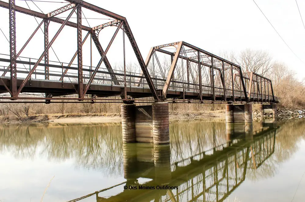
From there, the trail continues east, crossing the historic Wakonsa Bridge. It ends at the Neal Smith Trail on the Des Moines River’s east banks.
You can go north to Saylorville Lake or south to downtown Des Moines from the Neal Smith Trail. And on the river’s west banks, access the Trestle-to-Trestle Trail to head north to Johnston.
Know Before You Go!
- Inter-Urban Trail may be short. But it’s unique and super useful for connecting to the Neal Smith and the Trestle to Trestle Trails.
- The trail’s west endpoint is officially Urbandale Avenue and 34th Street. Still, bike lanes along Urbandale Avenue continue west of the trail.
- The trail crosses an old 615-foot long trestle bridge at the Des Moines River. It was built in 1905 and called the Wakonsa Bridge, after the Wakonsa Park neighborhood.
- Just north of the Inter-Urban trail, hop off the Trestle to Trestle trail to hike or mountain bike the South Sycamore trails.
Trail Map
Before you head out, plan your route with the interactive map from the Des Moines Metro Planning. And check out the Street Collective’s Regional Trails Map.
Trailheads
Access the trail along Urbandale Avenue. You can get on at 30th or 34th Streets, on either side of Beaverdale Park. Parking is available in the park.
The only way to get on the trail’s east end is via the Neal Smith Trail, east of the Des Moines River.
You can also park at McHenry Park and take the McHenry Park Trail south to the Neal Smith Trail. From there, turn right on Neal Smith to access the Inter-Urban Trail.
Connecting Trails
The Neal Smith Trail connects on the Des Moines River’s east banks, near the trestle bridge. From there, you can go north toward Saylorville Lake and Big Creek State Park. Or you can head south toward downtown Des Moines, where you’ll find an extensive trail network.
The Trestle to Trestle Trail connects on the Des Monies River’s west banks, near the trestle bridge. From here, you can head north toward Johnston.

Inter-Urban Trail Facts
- Location: North Des Moines
- Distance: 1.3 miles
- Surface: Asphalt
- Difficulty: Easy
- Description: The trail extends east through Beaverdale Park, past an urban area near MLK Pkwy, and across the river to Neal Smith Trail.
- Trailheads: Neal Smith Trail, 34th Street & Urbandale Avenue (near Beaverdale Park)
- Connectors: Neal Smith Trail, Trestle to Trestle Trail, Urbandale Avenue bike lanes